Frankfort Springs, Pennsylvania
Frankfort Springs, Pennsylvania | |
|---|---|
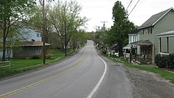
 Route 18 in Frankfort Springs | |
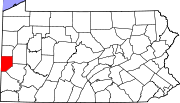
 Location in Beaver County and the U.S. state of Pennsylvania. | |
| Coordinates: 40°28′52″N 80°26′34″W / 40.48111°N 80.44278°W | |
| Country | United States |
| State | Pennsylvania |
| County | Beaver |
| Settled | 1772 |
| Incorporated | 1844 |
| Government | |
| • Type | Borough Council |
| Area | |
• Total | 0.26 sq mi (0.67 km2) |
| • Land | 0.26 sq mi (0.67 km2) |
| • Water | 0.00 sq mi (0.00 km2) |
| Elevation | 1,122 ft (342 m) |
| Population | |
• Total | 116 |
| • Density | 446.15/sq mi (172.17/km2) |
| Time zone | UTC-5 (Eastern (EST)) |
| • Summer (DST) | UTC-4 (EDT) |
| Area code | 724 |
| FIPS code | 42-27312 |
Frankfort Springs is a borough in southern Beaver County, Pennsylvania, United States.[3] The population was 116 at the 2020 census.[4] It is a part of the Pittsburgh metropolitan area.
Surrounding neighborhoods
[edit]Frankfort Springs has two borders, with Hanover Township to the north, east and west and with Washington County's Hanover Township to the south.
Demographics
[edit]| Census | Pop. | Note | %± |
|---|---|---|---|
| 1860 | 207 | — | |
| 1870 | 155 | −25.1% | |
| 1880 | 142 | −8.4% | |
| 1890 | 180 | 26.8% | |
| 1900 | 128 | −28.9% | |
| 1910 | 144 | 12.5% | |
| 1920 | 95 | −34.0% | |
| 1930 | 110 | 15.8% | |
| 1940 | 147 | 33.6% | |
| 1950 | 149 | 1.4% | |
| 1960 | 180 | 20.8% | |
| 1970 | 144 | −20.0% | |
| 1980 | 187 | 29.9% | |
| 1990 | 134 | −28.3% | |
| 2000 | 130 | −3.0% | |
| 2010 | 130 | 0.0% | |
| 2020 | 116 | −10.8% | |
| 2021 (est.) | 115 | [4] | −0.9% |
| Sources:[5][6][7][2] | |||

As of the 2000 census,[6] there were 130 people, 48 households, and 33 families residing in the borough. The population density was 520.4 inhabitants per square mile (200.9/km2). There were 51 housing units at an average density of 204.1 per square mile (78.8/km2). The racial makeup of the borough was 100.00% White. Hispanic or Latino of any race were 0.77% of the population.
There were 48 households, out of which 22.9% had children under the age of 18 living with them, 52.1% were married couples living together, 10.4% had a female householder with no husband present, and 29.2% were non-families. 29.2% of all households were made up of individuals, and 8.3% had someone living alone who was 65 years of age or older. The average household size was 2.71 and the average family size was 3.32.
In the borough the population was spread out, with 20.0% under the age of 18, 13.1% from 18 to 24, 26.2% from 25 to 44, 26.2% from 45 to 64, and 14.6% who were 65 years of age or older. The median age was 40 years. For every 100 females, there were 88.4 males. For every 100 females age 18 and over, there were 92.6 males.
The median income for a household in the borough was $31,458, and the median income for a family was $32,292. Males had a median income of $26,667 versus $26,042 for females. The per capita income for the borough was $12,776. There were 12.8% of families and 21.5% of the population living below the poverty line, including 28.0% of under eighteens and 15.4% of those over 64.
Education
[edit]Children in Frankfort Springs are served by the South Side Area School District. The current schools serving Frankfort Springs are:
- South Side Elementary School – grades K–5
- South Side Middle School – grades 6–8
- South Side High School – grades 9–12
Notable people
[edit]- Warren S. Dungan – Lieutenant Governor of Iowa[8]
- Robert Martin – acting Governor of Oklahoma Territory from 1891 to 1892
- J. R. Miller – Christian author, pastor, Editorial Superintendent of the Presbyterian Board of Publication
References
[edit]- ^ "ArcGIS REST Services Directory". United States Census Bureau. Retrieved October 12, 2022.
- ^ a b "Census Population API". United States Census Bureau. Retrieved October 12, 2022.
- ^ "Borough of Frankfort Springs". Geographic Names Information System. United States Geological Survey, United States Department of the Interior. Retrieved December 16, 2022.
- ^ a b Bureau, US Census. "City and Town Population Totals: 2020-2021". Census.gov. US Census Bureau. Retrieved July 19, 2022.
{{cite web}}:|last1=has generic name (help) - ^ "Census of Population and Housing". U.S. Census Bureau. Retrieved December 11, 2013.
- ^ a b "U.S. Census website". United States Census Bureau. Retrieved January 31, 2008.
- ^ "Incorporated Places and Minor Civil Divisions Datasets: Subcounty Resident Population Estimates: April 1, 2010 to July 1, 2012". Population Estimates. U.S. Census Bureau. Archived from the original on June 11, 2013. Retrieved December 11, 2013.
- ^ Biographical Sketch of Warren Scott Dungan

